Teiki Mathieu Baillan surfing a self-made Alaya surfboard in Macaroni, Mentawaï, Indonesia. Photo by C. Naslain, 2009.
¡Disfrute y contribuya!
| Encontrar los mejores spots |
|
|
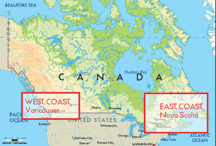
 Canada
América del Norte
Geographic coordinates:60 00 N, 95 00 W
Coastline:202,080 km
Climate:varies from temperate in south to subarctic and arctic in north
Terrain: mostly plains with mountains in west and lowlands in southeast
Natural hazards: continuous permafrost in north is a serious obstacle to development; cyclonic storms form east of the Rocky Mountains, a result of the mixing of air masses from the Arctic, Pacific, and North American interior, and produce most of the country's rain and snow east of the mountains
Currency:Canadian dollar (CAD)
Currency code:CAD
Ubicación: Northern North America, bordering the North Atlantic Ocean on the east, North Pacific Ocean on the west, and the Arctic Ocean on the north, north of the conterminous US
Coordenadas geográficas: 60° 0' N, 95° 0' W
Km de línea costera: 202,080 km km
Clima: varies from temperate in south to subarctic and arctic in north
Terreno: mostly plains with mountains in west and lowlands in southeast
Cumbres: lowest point: Atlantic Ocean 0 m
highest point: Mount Logan 5,959 m
Riesgos naturales: continuous permafrost in north is a serious obstacle to development; cyclonic storms form east of the Rocky Mountains, a result of the mixing of air masses from the Arctic, Pacific, and North American interior, and produce most of the country's rain and snow east of the mountains
Moneda: Canadian dollar (CAD)
Población: 33,098,932 (July 2006 est.)
Lenguas: English (official) 59.3%, French (official) 23.2%, other 17.5%
Capital: Ottawa
División administrativa: 10 provinces and 3 territories*; Alberta, British Columbia, Manitoba, New Brunswick, Newfoundland and Labrador, Northwest Territories*, Nova Scotia, Nunavut*, Ontario, Prince Edward Island, Quebec, Saskatchewan, Yukon Territory*
Más detalles
| Jan/Feb | Mar/Apr | May/Jun | Jul/Aug | Sep/Oct | Nov/Dec | |
|---|---|---|---|---|---|---|
| Best Surfing Season | ||||||
| Typical Swell Size | ||||||
| Surf Equipment | ||||||
| Water temp. | ||||||
| Air temp. | ||||||
| Climate | ||||||
Variaciones por estaciones de oleaje y de viento
¿Quiere añadir más informacion sobre Canada? Háganos saber...
¡Este es un mapa interactivo! Use los controles para recorrerlo y hacer zoom.
- Favoritos
-
Sus listas de spots de surf favoritos y futuros
¿Su zona favorita no está en la lista? Añadir una zona
Zonas
| Zonas (3) | Spots de surf | Sub-zonas |
|---|---|---|
| Great Lakes | 17 | 0 |
| West Coast | 30 | 0 |
| East Coast | 39 | 0 |
Spots de surf
| Spots de surf (2) | Calidad | Dirección | Tipo | Frecu | Experiencia | ||
|---|---|---|---|---|---|---|---|
| Bates Island, Ottawa River | 3 / 1 | Izquierda | Desembocadura | 
|
Surfistas con experiencia | ||
| Chambly Rapids | 1 / - | Derecha y izquierda | Desembocadura | 
|
Surfistas con experiencia |
 Fotos
Fotos

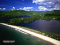
Cow bay - moose rocks |

Cow bay - moose rocks |
Ingonish beach |
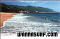
Ingonish beach |
Comentarios
Por NthWpgBasin , 27-01-2012
There Can Be waves up to about 9 feet on lake winnipeg. - The only great surfing spot is only accessable by jetski so only about a dozen people know about it. Its in the north basin where it goes from 20 foot water to about 5 foot water because of an underwater cliff.
Por Dan , 13-07-2008
Up North? - Had a mate from Yellowknife that swears the lake fetch barrels in... anybody ever been?
Por Neuf , 13-07-2007
No surf in Winnipeg - There is no surf in Winnipeg - trust me I live here! Great City and beaches but no waves.
Errores, opiniones.
Si quiere añadir nueva información o si ha encontrado errores en esta país, Envíe sus observaciones