¡Este es un mapa interactivo! Use los controles para recorrerlo y hacer zoom.
Acceso
|
Take a boat to Ollie's and instead of turning into the bay travel further North about 10 minutes or so. You can see on the gps, there's a little thing that looks like a pipline in the water. it's at the end of the pipeline. It's in the middle of the ocean. There's like a little bit of a rock mountain out there. the waves break on both North and south side of the pipeline (or what ever it was) and sort of do a big clap at the end. It was about 5 feet at the biggest. but fun. Better than 5 foot Ollies with 20 kooks. you maybe have to ask extra nice for your skipper to bring you there. It's not much further than Ollies,
English (Traducir este texto en Español): Take a boat to Ollie's and instead of turning into the bay travel further North about 10 minutes or so. You can see on the gps, there's a little thing that looks like a pipline in the water. it's at the end of the pipeline. It's in the middle of the ocean. There's like a little bit of a rock mountain out there. the waves break on both North and south side of the pipeline (or what ever it was) and sort of do a big clap at the end. It was about 5 feet at the biggest. but fun. Better than 5 foot Ollies with 20 kooks. you maybe have to ask extra nice for your skipper to bring you there. It's not much further than Ollies,
English (Traducir este texto en Español): Take a boat to Ollie's and instead of turning into the bay travel further North about 10 minutes or so. You can see on the gps, there's a little thing that looks like a pipline in the water. it's at the end of the pipeline. It's in the middle of the ocean. There's like a little bit of a rock mountain out there. the waves break on both North and south side of the pipeline (or what ever it was) and sort of do a big clap at the end. It was about 5 feet at the biggest. but fun. Better than 5 foot Ollies with 20 kooks. you maybe have to ask extra nice for your skipper to bring you there. It's not much further than Ollies,
English (Traducir este texto en Español): Take a boat to Ollie's and instead of turning into the bay travel further North about 10 minutes or so. You can see on the gps, there's a little thing that looks like a pipline in the water. it's at the end of the pipeline. It's in the middle of the ocean. There's like a little bit of a rock mountain out there. the waves break on both North and south side of the pipeline (or what ever it was) and sort of do a big clap at the end. It was about 5 feet at the biggest. but fun. Better than 5 foot Ollies with 20 kooks. you maybe have to ask extra nice for your skipper to bring you there. It's not much further than Ollies,
DistanciaNo sé
LlegadaNo sé
¿Fácil de encontrar?Hay que buscar un poco
¿Acceso publico?Acceso publico
Acceso especialSolamente por barco
|
|
Características de spot de surf
Nombre alternativo Gnardog Reef
Calidad del spot de surf
Calidad de las olasNormal
ExperienciaSurfistas con experiencia
FrecuenciaNo sé
Ola
TipoArrecife de corales
DirecciónDerecha
FondoArrecife (corales, rocas afiladas, etc...)
PotenciaVeloz, Divertida, Con salientes rocosas
Longitud normalNormal (50 a 150m)
Longitud máximaNormal (50 a 150m)
Marea, oleaje y viento
Buena dirección de la resacaOeste, Sudoeste, Sur
Dirección del vientoNorte
Talla de la resacaEmpieza en 1.0m-1.5m / 3ft-5ft y permanece hasta el No sé
Condición de mareaMarea mediana y marea baja
Mejor movimiento de mareaMarea descendente
Más detalles
Poblado durante la semanaVacío
Poblado en fines de semanaNo sé
Enlace Webcam
Peligros
- Rocas
Información adicional
Looks like if you went when the swell are coming in consistently at 6+feet. I could be a jem of a wave. It was about 4-5 feet (max) when i was there with three friends. My memory sort of evades me, there's a pipeline that goes all the way out to a big rock or little mountain . It's coral along what ever structure it is that goes out to the island. you can see it on the GPS. there's a right on the south side of the pipeline and a left on the North side of the pipeline. and they clap into one another. But other than the pipeline it's about 20 feet deep. Lots of fish, cool to get some underwater shots.
English (Traducir este texto en Español): Looks like if you went when the swell are coming in consistently at 6+feet. I could be a jem of a wave. It was about 4-5 feet (max) when i was there with three friends. My memory sort of evades me, there's a pipeline that goes all the way out to a big rock or little mountain . It's coral along what ever structure it is that goes out to the island. you can see it on the GPS. there's a right on the south side of the pipeline and a left on the North side of the pipeline. and they clap into one another. But other than the pipeline it's about 20 feet deep. Lots of fish, cool to get some underwater shots.
English (Traducir este texto en Español): Looks like if you went when the swell are coming in consistently at 6+feet. I could be a jem of a wave. It was about 4-5 feet (max) when i was there with three friends. My memory sort of evades me, there's a pipeline that goes all the way out to a big rock or little mountain . It's coral along what ever structure it is that goes out to the island. you can see it on the GPS. there's a right on the south side of the pipeline and a left on the North side of the pipeline. and they clap into one another. But other than the pipeline it's about 20 feet deep. Lots of fish, cool to get some underwater shots.
English (Traducir este texto en Español): Looks like if you went when the swell are coming in consistently at 6+feet. I could be a jem of a wave. It was about 4-5 feet (max) when i was there with three friends. My memory sort of evades me, there's a pipeline that goes all the way out to a big rock or little mountain . It's coral along what ever structure it is that goes out to the island. you can see it on the GPS. there's a right on the south side of the pipeline and a left on the North side of the pipeline. and they clap into one another. But other than the pipeline it's about 20 feet deep. Lots of fish, cool to get some underwater shots.
Ambiente
cool vibe, i'm sure people have surfed there before me, but you definitely feel like you could be the first one when you get out there. Maybe some big fish too, who knows.
English (Traducir este texto en Español): cool vibe, i'm sure people have surfed there before me, but you definitely feel like you could be the first one when you get out there. Maybe some big fish too, who knows.
English (Traducir este texto en Español): cool vibe, i'm sure people have surfed there before me, but you definitely feel like you could be the first one when you get out there. Maybe some big fish too, who knows.
English (Traducir este texto en Español): cool vibe, i'm sure people have surfed there before me, but you definitely feel like you could be the first one when you get out there. Maybe some big fish too, who knows.
General
fun time, watch out for the sharp coral if you eat $h1t.
English (Traducir este texto en Español): fun time, watch out for the sharp coral if you eat $h1t.
English (Traducir este texto en Español): fun time, watch out for the sharp coral if you eat $h1t.
English (Traducir este texto en Español): fun time, watch out for the sharp coral if you eat $h1t.
 Comentarios
Por favor regístrese para usar esta herramienta.
¿Aún no está registrado? Regístrese primero; ¡es gratis!
Mostrar todo (1)...
Errores, opiniones.
Puede editar esta página para corregir los errores y añadir nueva información. Si tiene otros comentarios sobre esta página, Envíe sus observaciones
Wannasurf.com 24/24
Wannasurf.com en su móvil

Boletín Todas las noticias por correo electrónico
 Scardog reef
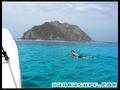
Por Kiki , 16-03-2010
- I have been going to Costa Rica for 8 years and every year we a take a trip or two to Ollie's. On March 12, 2010 we headed off to Ollie's and arrived at low tide with waist to chest waves. The boat captain requested to take us to La Isla a/k/a Scardog Reef. When we arrived it was the sketchiest set up I had ever seen from the boat. Once in the water it turned out to be a perfect right hand point break with nice drops and a 100 yard bowl right into a deep channel making for an easy paddle out. It was about head high, maybe bigger on sets. Probably bigger and it would have been epic becuase the wind was light north making it perfectly offshore. At the take off spot the reef is right there. Reminds me of Cane Garden Bay in Tortola